
Typhoon Khanun Intensifies After an Active Period in the West Pacific
It has been quite an active past few weeks in the Western Pacific Ocean. First, we were tracking Typhoon Talim, which made landfall in southern China while impacting parts of Vietnam [1]. Last week, all eyes were on Doksuri, which ended up impacting the Philippines harder than consensus predicted after jogging further south. Furthermore, Doksuri made landfall in mainland China as a more powerful typhoon that originally expected, landing in the Fujian province of China with maximum sustained winds of ~108 miles per hour (the equivalent of a strong category 2) [2]. Its slow movement both on approach to the Philippines and China means that both nations are still reeling from the massive rains and flooding the typhoon produced [3].
Despite all this, Doksuri is no more, and our attention now turns to a new typhoon in the Western Pacific. Typhoon Khanun is currently a category 4-equivalent cyclone with maximum sustained winds of 132 miles per hour. Unlike the previous typhoons we’ve been tracking, Khanun appears to be headed on a less direct path. See the latest forecast graphic from KinetiCastTM below:
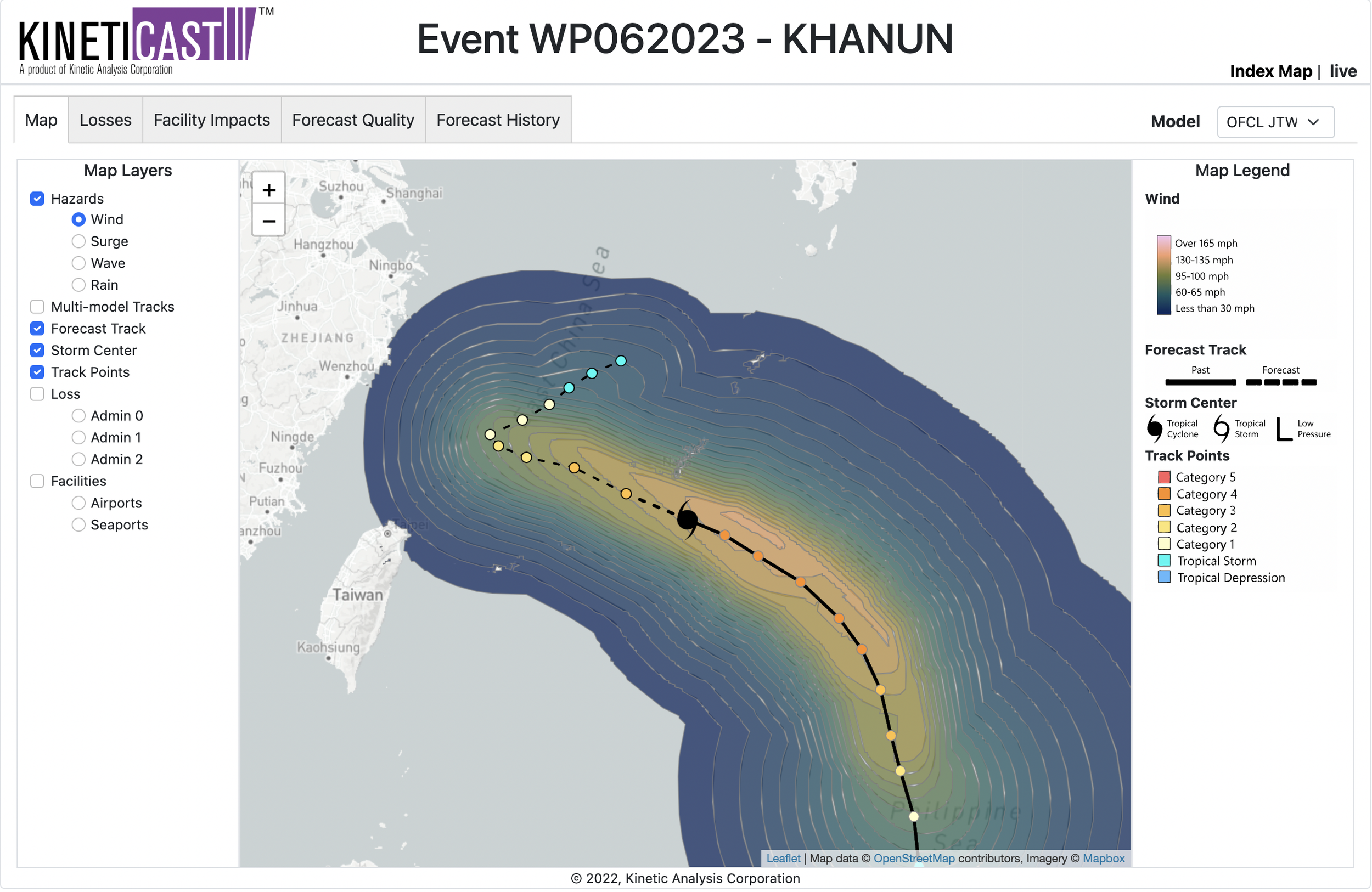
Figure 1: Projected wind swath of Typhoon Khanun, generated by KinetiCast™ models using forecast data from the Joint Typhoon Warning Center (JTWC). The solid hurricane symbol denotes the storm position for this forecast. The filled circles are color-coded by intensity. The circles on the dashed line represent the forecast position of the cyclone at 12-hour intervals, and the circles on the solid line depict the past position of the storm at 6-hour intervals.
Previous forecasts called for Khanun to make landfall in the Zhejiang province of China as a powerful typhoon [4]. However, more recent forecasts show an abrupt slowdown of the typhoon followed by a right-hand turn (Figure 1). As is more apparent in Figure 2, Khanun will come very close to the southern Japanese island of Okinawa. With a population of roughly 1.5 million residents, much of the island is likely to be affected by winds up to 100 miles per hour, storm surge, and torrential rains [5, 6]. In fact, rainfall may be the biggest threat from Khanun due to its projected decrease in forward motion. Figure 3 shows a large area of upwards of 24 inches of rain that is expected to fall in Okinawa and the surrounding islands over the next few days. This could prove to be especially hazardous even if a direct hit from Khanun is avoided altogether.
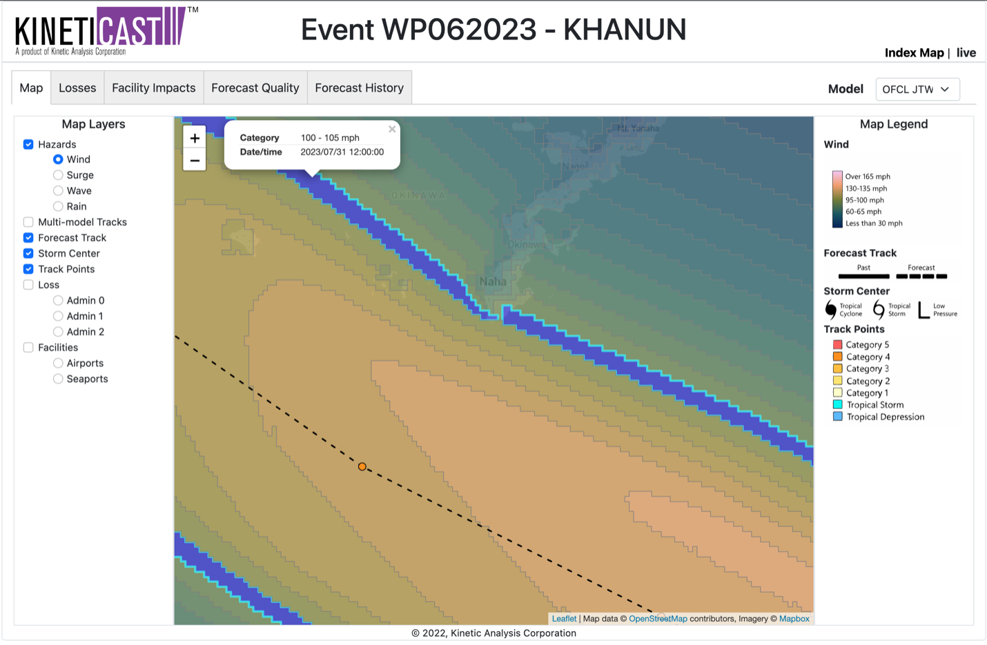
Figure 2: Zoomed-in view of forecast wind swath from Typhoon Khanun as it approaches the island of Okinawa. The blue highlighted band is used to show the potential wind speeds that could impact parts of the island.
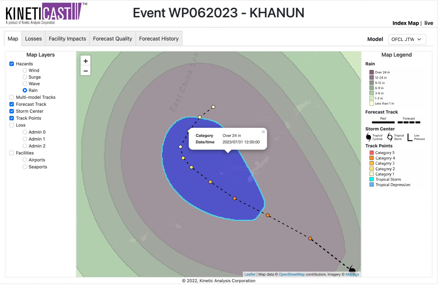
Figure 3: Forecast rainfall from Typhoon Khanun, generated by KinetiCast™ models using forecast data from the Joint Typhoon Warning Center (JTWC).
Several typhoons have formed recently in the Western Pacific and affected land, but there could be no respite in the offing as tropical cyclone activity will likely ramp up globally in the next few months as the climatological peak season approaches in the Atlantic and Pacific basins [7, 8, 9]. Here at Kinetic Analysis Corporation, we provide you with accurate, near real-time information about a tropical cyclone as it unfolds. We do this by synthesizing information from a variety of sources and translating the meteorological hazards into easily digestible impact information. This includes populations affected by tropical storm/hurricane force winds and storm surge, economic loss and structural damage estimates, and shutdown times for facilities such as airports and seaports. All this information is available in our state-of-the-art web app, KinetiCast™. Now for a limited time, we are offering the next 10 people who sign up to use KinetiCast™ a basic license that includes all the hazard information for just $25/month. If you would like more information, please reach out to aagastra@kinanco.com.
References
1. https://www.aljazeera.com/news/2023/7/18/tens-of-thousands-flee-as-typhoon-talim-lashes-china-vietnam
2. https://www.cnn.com/2023/07/28/asia/typhoon-doksuri-china-landfall-intl-hnk/index.html
3. https://www.bbc.com/news/world-asia-china-66369137
4. https://www.reuters.com/world/asia-pacific/khanun-forms-china-warns-third-typhoon-three-weeks-2023-07-29/
5. https://yaleclimateconnections.org/2023/07/khanun-to-rake-okinawa/
6. https://www.newsdirectory3.com/typhoon-kanun-approaching-okinawa-and-amami-strict-vigilance-required/
7. https://www.e-education.psu.edu/meteo3/l12_p3.html
8. https://www.nhc.noaa.gov/climo/#:~:text=The%20official%20hurricane%20season%20for,%2DAugust%20and%20mid%2DOctober.
9. https://weather.com/storms/hurricane/news/2019-07-30-western-pacific-strangely-quiet