Tropical Storm Nicole to Impact Florida and the US East Coast
Tropical Storm Nicole is currently located over the Bahamas and is just shy of becoming a category 1 hurricane. The late-season storm originally formed from a system that had both tropical and non-tropical characteristics (making it subtropical) but is now fully tropical and has the potential to reach hurricane strength. A notable aspect of Nicole is the large radius of tropical storm force winds extending beyond the center of circulation. See the image from KinetiCast™ below.
Forecast wind swath of Tropical Storm Nicole, generated by KinetiCast™ models using forecast data from the Joint Typhoon Warning Center. The 40-45 mph wind speed band has been highlighted to show how far tropical storm force winds extend outward from the center of circulation.
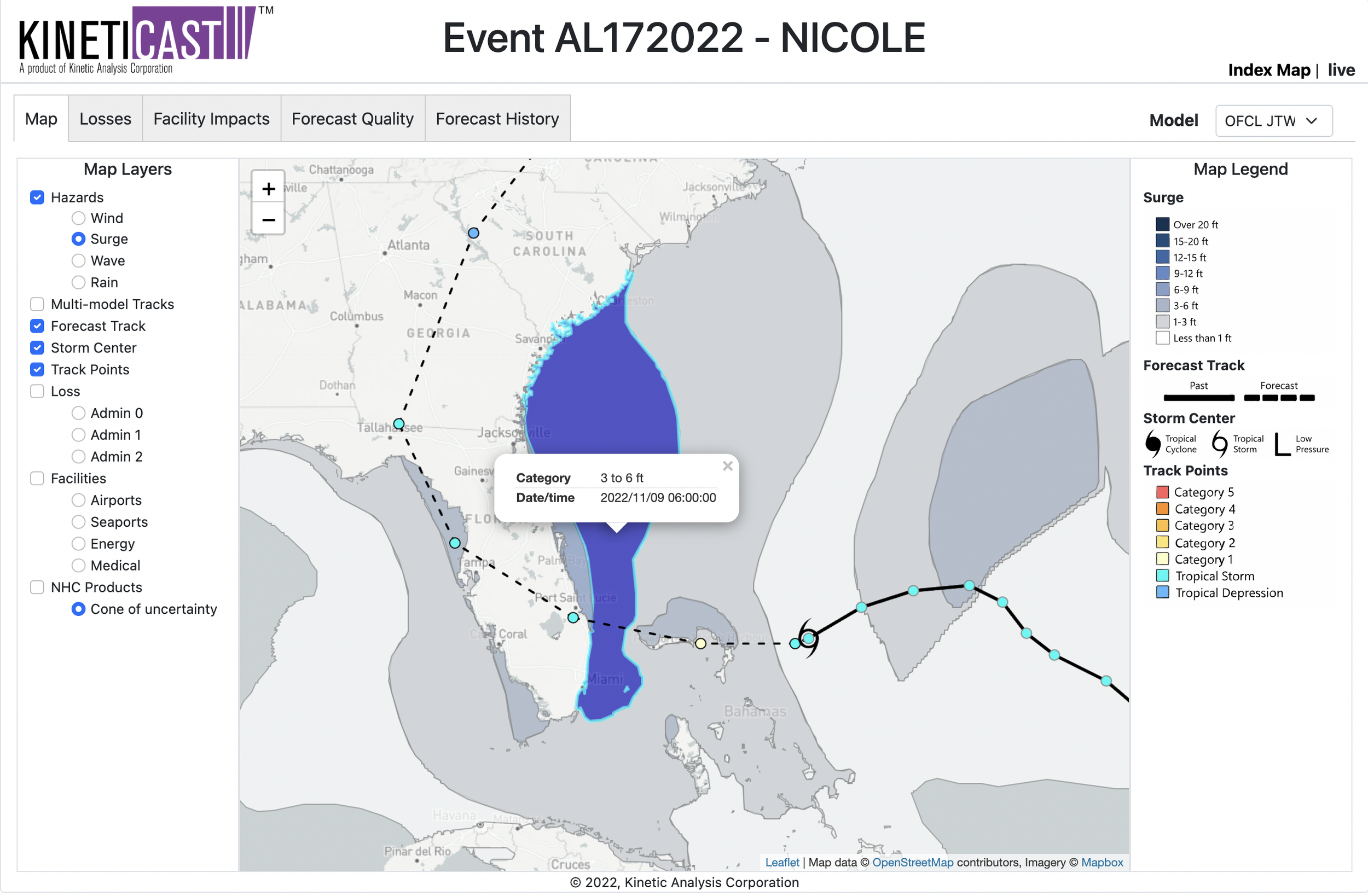
The expansive wind field of Nicole means that a large portion of the state of Florida will see wind-related impacts. An additional hazard brought on by the wind is storm surge, which is also predicted to be elevated as Nicole approaches the coastline. Combined with the large area of winds around the center of circulation, the persistent onshore flow to the north as Nicole approaches the coastline of Florida, and the fact that tides have been running higher than normal due to a full moon, Nicole could produce a wide area of storm surge as high as 3-6 feet and potentially up to 6-9 feet in more isolated areas (see image below).
Forecast storm surge for Tropical Storm Nicole, generated by KinetiCast™ models using forecast data from the Joint Typhoon Warning Center. The surge calculation includes the cumulative effects of wind-driven water rise and effects due to tides. The 3 to 6 ft band is highlighted to show the expansive area of the southeast U.S. coastline that could see elevated water levels and coastal flooding as Nicole approaches.
As Nicole makes landfall in Florida, it is forecast to turn to the north and eventually northeast and accelerate. This will make it a concern for the entire U.S. east coast as well, with heavy rainfall, high winds, and flooding a potential issue from Florida all the way up to New England. The current projections on KinetiCast™ place the losses from Nicole at over 2 billion USD in PPP. Changes to the loss numbers and impacts will be updated on KinetiCast™ in real-time as the storm approaches. If you would like to track these changes and stay ahead of future storms yourself, please reach out to sales@kinanco.com.


