
Tropical Storm Idalia a Significant Threat to Florida and the Southeastern USA
Tropical Storm Idalia, born out of the western Caribbean over the weekend, is poised to make a significant landfall somewhere along the west coast of Florida. As of the latest advisory from the National Hurricane Center, Idalia had maximum sustained winds of 65 miles per hour. It is predicted to strengthen into a hurricane later today and a major hurricane (category 3 or higher) by Tuesday night into Wednesday morning. The latest forecast wind graphic from KinetiCast™ is displayed below:
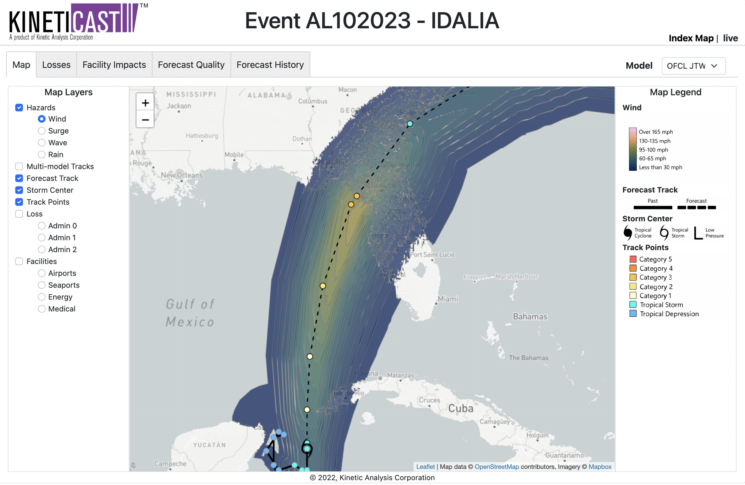
Figure 1: Projected wind swath of Tropical Storm Idalia, generated by KinetiCast™ models using forecast data from the National Hurricane Center. The open tropical cyclone symbol denotes the storm position for this forecast. The filled circles are color-coded by intensity. The circles on the dashed line represent the forecast position of the cyclone at 12-hour intervals, and the circles on the solid line depict the past position of the storm at 6-hour intervals.
As the colored circles denote in Figure 1, the current expectation is that Idalia will become a category 3 hurricane before making landfall somewhere in the Big Bend region of Florida. However, it is possible that the storm may be stronger or weaker and that the track may be further to the left or to the right of the forecast. As we have seen all too often with landfalling tropical cyclones, intensity is notoriously difficult to forecast [1, 2]. In particular, rapid intensification (RI) events are not always well-depicted by weather models, with current models accurately predicting RI only 32% of the time [2].
One recent storm that intensified more quickly than initially expected was Hurricane Ida in 2021, which strengthened by a whopping 65 miles per hour in wind speed in just 24 hours [3]. This example is not meant to claim that Idalia will strengthen as rapidly as Ida did, as every storm and the environment around each storm is different. Instead, it is meant to convey the present natural level of uncertainty that exists when forecasting the intensity of tropical cyclones. In addition, the waters in the Gulf of Mexico this summer have been anomalously warm due to numerous heat waves and record high temperatures throughout the southern United States [4]. On average, sea surface temperatures are running 1-2 degrees Celsius warmer than normal in the part of the Gulf of Mexico that Idalia will traverse [4], with many readings near 90°F. This means that the ceiling for Idalia is very high, and not only could the storm rapidly intensify, but it has the potential to do so in a manner that surpasses even the expectations from forecasters and the National Hurricane Center. Thus, residents and agencies should prepare for Idalia how they would prepare for any major hurricane making landfall in their neck of the woods.
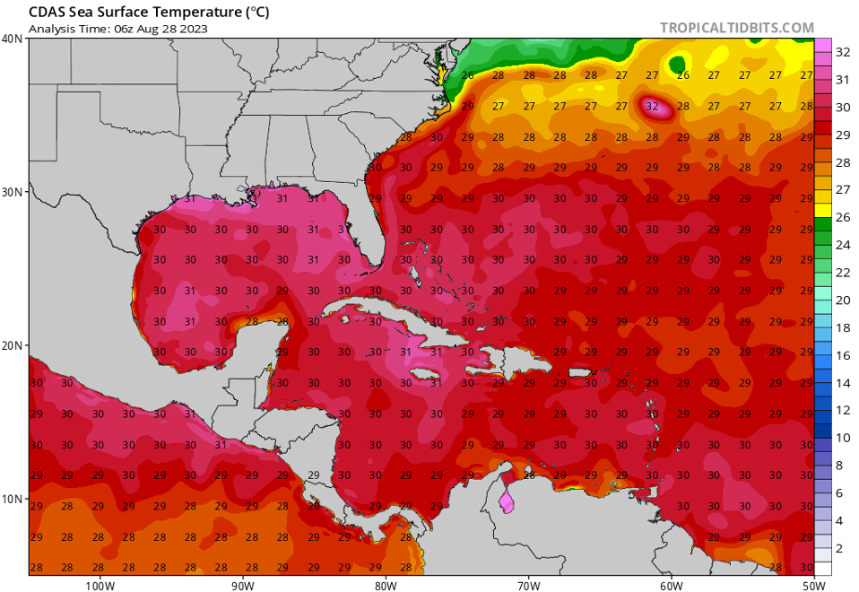
Figure 2: Sea surface temperatures (in degrees Celsius) for the western Atlantic and Gulf of Mexico as of 06 UTC on August 28.
Source: https://www.tropicaltidbits.com/analysis/ocean/
The current storm surge forecast for Idalia (Figure 3) calls for as much as 9 to 12 feet of potential inundation just to the north of Tampa Bay, around Cedar Key, Florida. However, even the entirety of Tampa Bay could see storm surge of 3 to 6 feet. Any shifts to the track and intensity of Idalia as it approaches Florida will impact which communities see the most significant impacts from storm surge. It is also important to note that, due to the persistent onshore flow as Idalia approaches the coastline, even areas of southwest Florida hit hard by Hurricane Ian last year could see water-level rises of 1 to 3 feet.
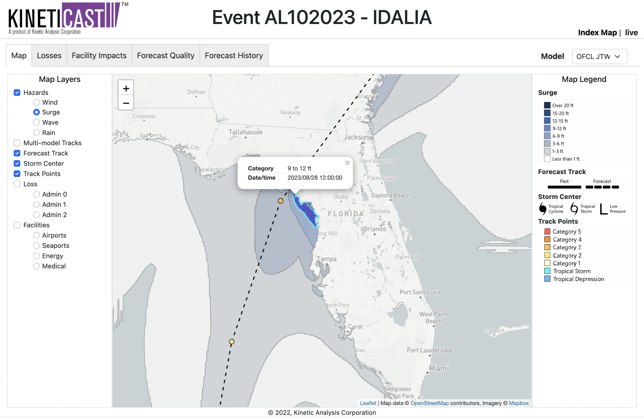
Figure 3: Forecast storm surge for Tropical Storm Idalia, generated by KinetiCast™ models using forecast data from the National Hurricane Center. The surge calculation includes the cumulative effects of pressure, wave setup, wind-driven water rise, and effects due to tides.
With regards to the economic impact, Idalia is expected to be a multi-billion-dollar disaster. This is especially noteworthy after Hurricane Ian caused record losses to the Florida property insurance industry just last year [5]. The economic impact from Idalia will extend well beyond Florida, with coastal Georgia, South Carolina, and North Carolina also seeing significant impacts. Should Ian remain slightly offshore of Georgia and the Carolinas, as is the current expectation, the storm could restrengthen or at least maintain its post-Florida intensity while continuing to push ocean water into vulnerable, low-lying communities. The current economic impact forecast on KinetiCast™ is just under 7 billion USD in Purchasing Power Parity, or PPP. (PPP is used to allow for quick comparisons between countries of different economic levels). As with other aspects of the storm, the forecast economic impact is likely to change should there be changes in the forecast track or intensity of Idalia over the next couple of days.
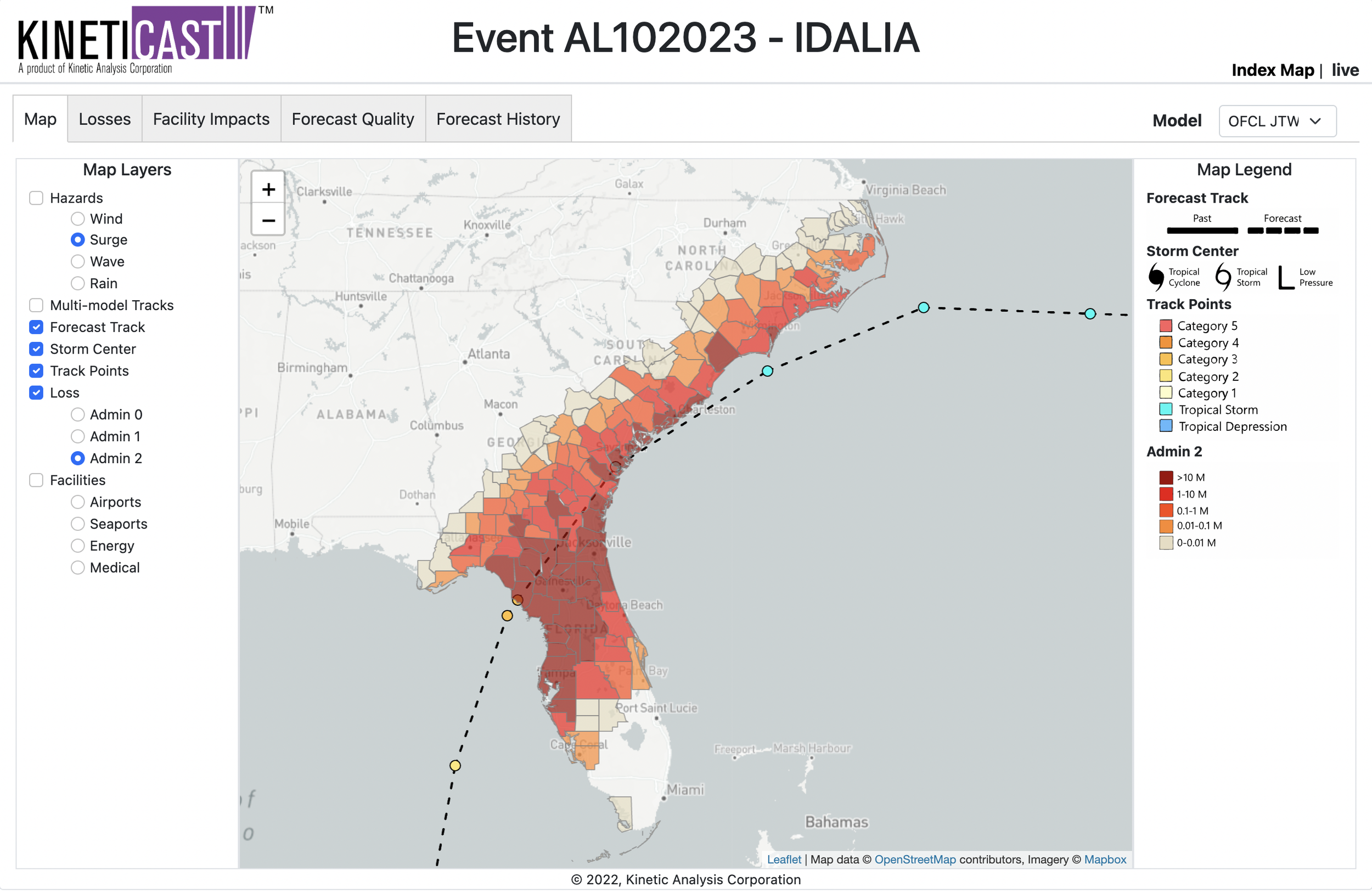
Figure 4: Forecast economic loss from Idalia in Purchasing Power Parity for the southeastern USA. The losses are displayed for administrative level 2 boundaries, which represent counties in the U.S.
Activity continues to ramp up in the Atlantic Ocean. Despite an El Niño year [6], we already could be looking at a major hurricane impact for the continental United States. Now is the time to ensure that you/your organization have an organized hurricane response plan in place. At Kinetic Analysis Corporation, our goal is to facilitate hurricane preparedness by providing you with accurate, near real-time information about a tropical cyclone as it unfolds. We do this by synthesizing data from a variety of sources and translating the meteorological hazards into easily digestible impact information. This includes populations affected by tropical storm/hurricane force winds and storm surge, economic loss and structural damage estimates, and shutdown times for facilities such as airports and seaports. All this information is available in our state-of-the-art web app, KinetiCast™. If you would like more information, please reach out to aagastra@kinanco.com.
References
1. https://www.umass.edu/mathematics-statistics/sites/default/files/file-attachments/hurricane_modeling_writeup-3.pdf
2. https://www.scientificamerican.com/article/new-hurricane-forecasts-could-predict-terrifying-explosive-intensification/
3. https://www.cnn.com/2023/08/17/weather/rapid-intensification-hurricane-xpn-scn/index.html
4. https://www.axios.com/2023/08/28/idalia-forecast-florida-rapid-intensification-florida
5. https://www.insurancebusinessmag.com/us/news/catastrophe/florida-insurer-losses-spiral-after-hurricane-ian-427355.aspx
6. https://iri.columbia.edu/our-expertise/climate/forecasts/enso/current/
7. https://www.tropicaltidbits.com/analysis/ocean/