
The 2024 Atlantic Hurricane Season Begins
The hurricane season in the North Atlantic officially kicked off on Saturday, June 1. Right now, there is no activity or potential systems to monitor. In fact, the hurricane seasons in both the Atlantic and the Eastern Pacific (the latter of which began on May 15) have been surprisingly quiet thus far. Compared to the last several years of pre-season activity and named storms, what is likely driving this lull?
It’s important to mention that atmospheric conditions early in the hurricane season, particularly over the Atlantic, are usually hostile to the formation of tropical cyclones. Thus, early season storms are usually the result of a larger scale feature such as the Monsoon Trough or the Madden Julian Oscillation (MJO). The Monsoon Trough is a transient feature characterized by an elongated area of low pressure that usually sits along the Intertropical Convergence Zone (ITCZ) [1]. The ITCZ is a band that encircles Earth near the equator, where trade winds from the Northern and Southern Hemisphere come together (Figure 1) [2]. Strong radiation from the sun and the warmer waters near the equator heat the air near the ITCZ, raising its humidity and making it more buoyant. The combination of the humid, buoyant air and the convergence of the trade winds promotes the upward convection of air in the ITWC. As the humid air rises, it expands and cools, releasing the accumulated moisture in a seemingly persistent series of thunderstorms [2].
So far in 2024, the Monsoon Trough over the Atlantic and Eastern Pacific has been somewhat lackluster. This is likely the result of an MJO phase that has favored rising air and convection over the Indian Ocean/Western Pacific instead of areas to the east (see Figure 2) [3]. The MJO is an eastward-propagating feature in the atmosphere characterized by an area of rising air and enhanced rainfall and a compensatory area of sinking and suppressed air [4]. The pattern for the last couple weeks has favored subsiding air over the Atlantic and Eastern Pacific [3]. This may change soon, however. Models show that by the middle to end of the month, the phase of the MJO will favor rising air over the Eastern Pacific and North Atlantic oceans. Once this rising motion is enhanced, it is likely inevitable that we will get a storm to form in the Atlantic or Pacific (or both basins).
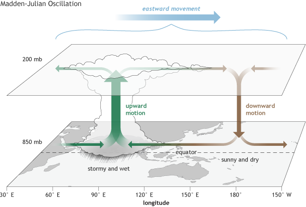
Figure 2: Schematic showing the phase of the MJO when upward motion and enhanced convection is centered over the Indian Ocean. Horizontal arrows pointing left represent wind departures from average that are easterly, and arrows pointing right represent wind departures from average that are westerly. The entire system shifts eastward over time, eventually circling the globe and returning to its point of origin. Image credit: https://www.climate.gov/news-features/blogs/enso/what-mjo-and-why-do-we-care
In the Atlantic, the factors that drive tropical cyclone formation and intensification remain highly favorable for the time being. Sea surface temperatures (SSTs) remain at record warm levels throughout the Main Development Region [5], and this is likely to persist over the next few months. In particular, they are quite warm across the Caribbean (Figure 3), which raises the threat of rapid intensification of tropical cyclones heading into the summer and fall. This is because once sea surface temperatures rise above 83/84 degrees Fahrenheit, fully-formed hurricanes are much more likely to undergo rapid intensification, particularly when wind shear isn’t strong [5]. With ENSO neutral conditions now being realized and a potentially strong La Niña predicted to develop by the peak of the season, this raises the chances for lower-than-normal wind shear across the tropical Atlantic and Caribbean Sea [6]. Figure 4 shows the SST anomalies for the globe. While the tropical Atlantic remains anomalously warm to a significant degree, the equatorial Pacific has developed a noticeable tongue of colder-than-normal SSTs due to the onset of La Niña.

Figure 3: Weekly sea-surface temperature in the Caribbean Sea in 2024 (black) compared to observations since 1981 (grey lines) and the 1981-2021 average (red). Graphic borrowed from https://yaleclimateconnections.org/2024/05/what-you-need-to-know-about-record-breaking-heat-in-the-atlantic/
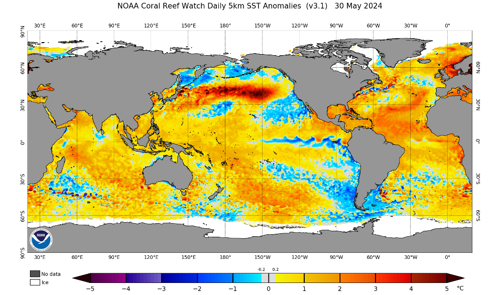
Figure 4: Sea surface temperature anomalies from the National Oceanic and Atmospheric Administration Coral Reef Watch, valid for May 30, 2024.
In the end, no forecast or agency can predict (with 100% certainty) how bad the hurricane season may be and which locations are most likely to be affected. Just like with any hurricane season, residents along vulnerable coastlines and hurricane-prone areas need to prepare as if this will be the year they are hit. It’s important to have a hurricane plan in place, including access to real-time information well before the storm approaches your area.
Here at Kinetic Analysis Corporation, it’s our job to make sure you are prepared before disaster strikes. We’ve recently upgraded our web app, KinetiCast™, to allow users to upload their own assets and receive alerts in real-time (up to 5 days in advance) whenever their properties are forecast to be impacted. These alerts include information such as the estimated loss to the structure and its contents, the estimated shutdown/evacuation time, and the downtime in days. This type of critical information could be just what you need to protect your business, alert as many of your clients to oncoming hazards, and protect as many lives and as much property as possible. For more information about the plans and data we offer, please reach out to aagastra@kinanco.com.
References
1. https://www.nhc.noaa.gov/marine/docs/USA_Glossary.pdf
2. https://earthobservatory.nasa.gov/images/703/the-intertropical-convergence-zone
3. https://www.cpc.ncep.noaa.gov/products/precip/CWlink/MJO/mjo.shtml
4. https://www.climate.gov/news-features/blogs/enso/what-mjo-and-why-do-we-care
5. https://yaleclimateconnections.org/2024/05/what-you-need-to-know-about-record-breaking-heat-in-the-atlantic/
6. https://www.noaa.gov/news-release/noaa-predicts-above-normal-2024-atlantic-hurricane-season