Tropical Cyclone Freddy Heads Toward Vulnerable Madagascar
Tropical Cyclone Freddy, a storm that earlier this month originated off the northwestern coast of Australia, is on a collision course with the island nation of Madagascar. Freddy, the strongest cyclone of 2023 as of yet (and the first to reach category 5 intensity this year – so far having topped out at 165 miles per hour), is unusual in many regards [1]. For one, the sheer intensity of the cyclone makes it one of the strongest ever to exist in the month of February anywhere on the Earth [1]. In addition, the track of the cyclone thus far is relatively unparalleled since satellite observations of tropical cyclones began. The only storm in recent history that follows a similar track to Freddy, forming off the Australian coast and taking a roughly east-to-west trajectory across the southern Indian Ocean, is Tropical Cyclone Leon-Eline in February of 2000 (see figure below) [2].
Track of Tropical Cyclone Leon-Eline (2000), created by Supportstorm using WikiProject Tropical cyclones/Tracks. The background image is from NASA. Tracking data is from the International Best Track Archive for Climate Stewardship (IBTrACS).
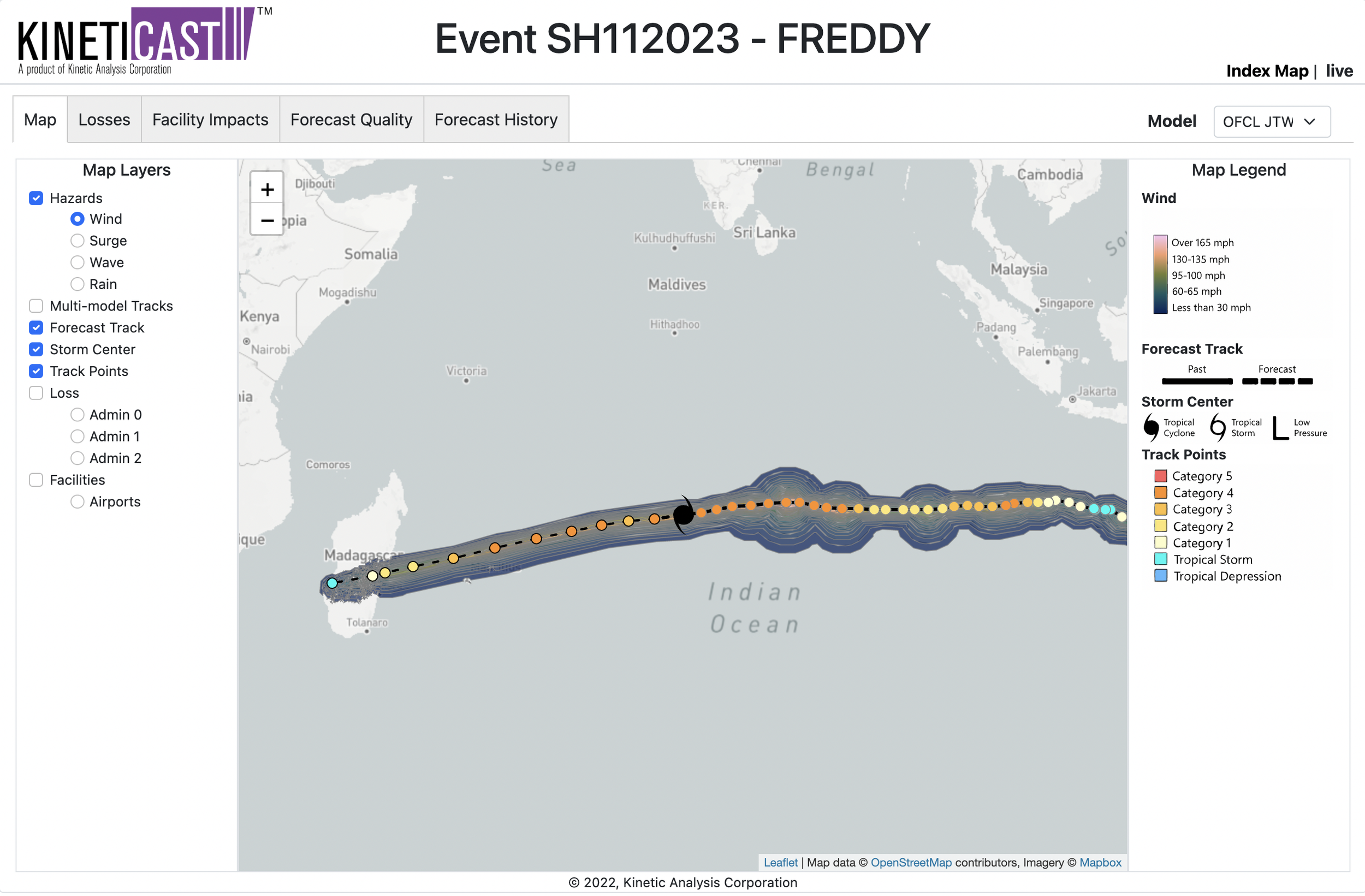
However, the track of Cyclone Freddy is not the only aspect that makes this storm unique. We can also look at the accumulated cyclone energy (ACE) of the storm, which is a metric used to describe the total amount of energy released by a tropical cyclone over its lifetime [4]. ACE is directly related to the sum of the squares of the maximum sustained winds of the tropical cyclone (measured every 6 hours) and the length of time the tropical cyclone existed [5]. Thus, cyclones that are particularly intense and last for longer periods of time will generate the highest ACE values. As of the latest advisory released at 1200 UTC by the Joint Typhoon Warning Center, the current ACE generated by Cyclone Freddy is 42.6 units [7]. The highest ACE generated by a single tropical cyclone anywhere in the Southern Hemisphere is that of Cyclone Fantala in 2016 (53 ACE) [1]. With that in mind, let’s look at the projected path and forecast of Freddy as displayed on KinetiCast™.
Projected wind swath of Tropical Cyclone Freddy, generated by KinetiCast™ models using forecast data from the Joint Typhoon Warning Center. The filled in circles represent the past/forecast path of the cyclone color-coded by intensity.
As the figure above shows, Freddy will likely continue to traverse the southwestern Indian Ocean near peak strength, maintaining at least Category 4-equivalent intensity for the next couple of days. The storm is likely to rack up significant additional ACE during this time, making it a contender to break the Southern Hemisphere record for the most ACE generated by a single storm.
When looking at the projected track of Freddy, the storm is likely to come uncomfortably close to the islands of Mauritius and Réunion. Beyond this point, Freddy will also likely impact Madagascar, which has already been left vulnerable following previous cyclones in the 2022-2023 Southern Indian Ocean season [6]. Cyclone Cheneso (see our previous blog post here) dumped copious amounts of rainfall on the island last month, leaving soils saturated and communities reeling from flooding [6]. The prior impacts from Cheneso and the strength and unique nature of Freddy make for a combination that could potentially be devastating for Madagascar.
Now for a limited time, Kinetic Analysis Corporation is offering a free trial period of our state-of-the-art tropical cyclone tracking tool, KinetiCast™. During this trial period, users will be able to access all the hazard and loss layers from Cyclone Freddy, as well as facility impacts information (such as shutdowns to airports and hospitals and the forecast history and quality from various numerical weather prediction models). We are offering this free trial as an opportunity for users to test out our products and see if they could be helpful in their business practices. If you are interested in learning more, please reach out to me at aagastra@kinanco.com.
References:
https://www.ncei.noaa.gov/products/international-best-track-archive
https://www.cpc.ncep.noaa.gov/products/outlooks/Background.html
http://tropical.atmos.colostate.edu/Realtime/index.php?loc=southernhemisphere


