Cyclone Cheneso Makes a Comeback
Cyclone Cheneso, the same tropical storm that dumped heavy rainfall on Madagascar in recent days, has reemerged and reintensified over the Mozambique Channel. While current forecasts from the Joint Typhoon Warning Center (JTWC) predict the storm will stay offshore, it is likely to continue to strengthen into a powerful tropical cyclone. The Mozambique Channel is a climatologically favored region for the intensification of tropical cyclones, particularly ones that have previously crossed the island of Madagascar. See the figure below from NOAA [1].
Historical hurricane tracks (1980 to 2020) that passed near Madagascar, color-coded by intensity at a given location (blue: tropical depression, green: tropical storm, yellow: category 1, orange: category 2, red: category 3, pink: category 4, and purple: category 5. Image retrieved from https://coast.noaa.gov/hurricanes/
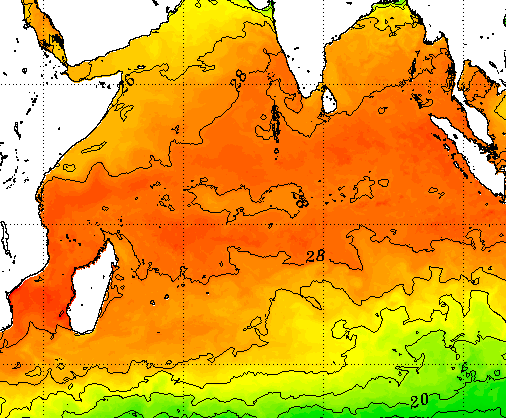
The figure above shows several systems that, after crossing Madagascar and weakening, tend to quickly intensify once remerging over the Mozambique Channel (between mainland Africa and Madagascar), with some going on to affect parts of the African continent. This intensification trend is largely due to the Mozambique Channel containing some of the warmest water anywhere in the southwest Indian Ocean [2].
Contoured sea-surface temperature map from NOAA as of January 24, 2023, for the Indian Ocean region, showing areas of warmer sea-surface temperatures (darker oranges and reds) compared to cooler sea-surface temperatures (lighter yellows and greens). Image retrieved from https://www.ospo.noaa.gov/Products/ocean/sst/contour/index.html
Going forward, Cheneso will continue to intensify; the current forecast from JTWC calls for a category 3 equivalent cyclone with maximum sustained winds of 115 miles per hour. It is fortunate that the cyclone will remain offshore during this time. However, it is only a matter of time before the next major storm affects parts of the southwest Indian Ocean.
Forecast wind swath of Cyclone Cheneso, generated by KinetiCast™ models using forecast data from the Joint Typhoon Warning Center.
Kinetic Analysis Corporation is offering now, for a limited time, a free trial period of our state-of-the-art tropical cyclone tracking tool, KinetiCast™. During this trial period, users will be able to access all the hazard and loss layers from Cheneso, as well as facility impacts information (such as shutdowns to airports and hospitals and the forecast history and quality from various numerical weather prediction models. We are offering this free trial as an opportunity for users to test out our products and see if they could be helpful in their business practices. If you are interested in learning more, please reach out to sales@kinanco.com.
References
1. https://coast.noaa.gov/hurricanes/
2. https://www.ospo.noaa.gov/Products/ocean/sst/contour/index.html


