Hurricane Lee to Brush Bermuda; Impacts Expected this Weekend in Canada and the Northeast USA
Hurricane Lee, a system that to date has largely remained in the open ocean, is forecast to brush Bermuda in the next day or so. Lee is a long-tracked hurricane that previously reached category 5 intensity, with maximum sustained winds of 160 mph. Since then, the storm has been on a weakening trend due to moving into over cooler sea surface temperatures and into an environment with modest wind shear [1]. However, with this weakening there has also been a significant expansion in tropical storm and hurricane-force winds around the center of Lee [2]. This means that tropical storm impacts are expected in Bermuda, despite the center of the hurricane passing over a hundred miles to the west of the island.
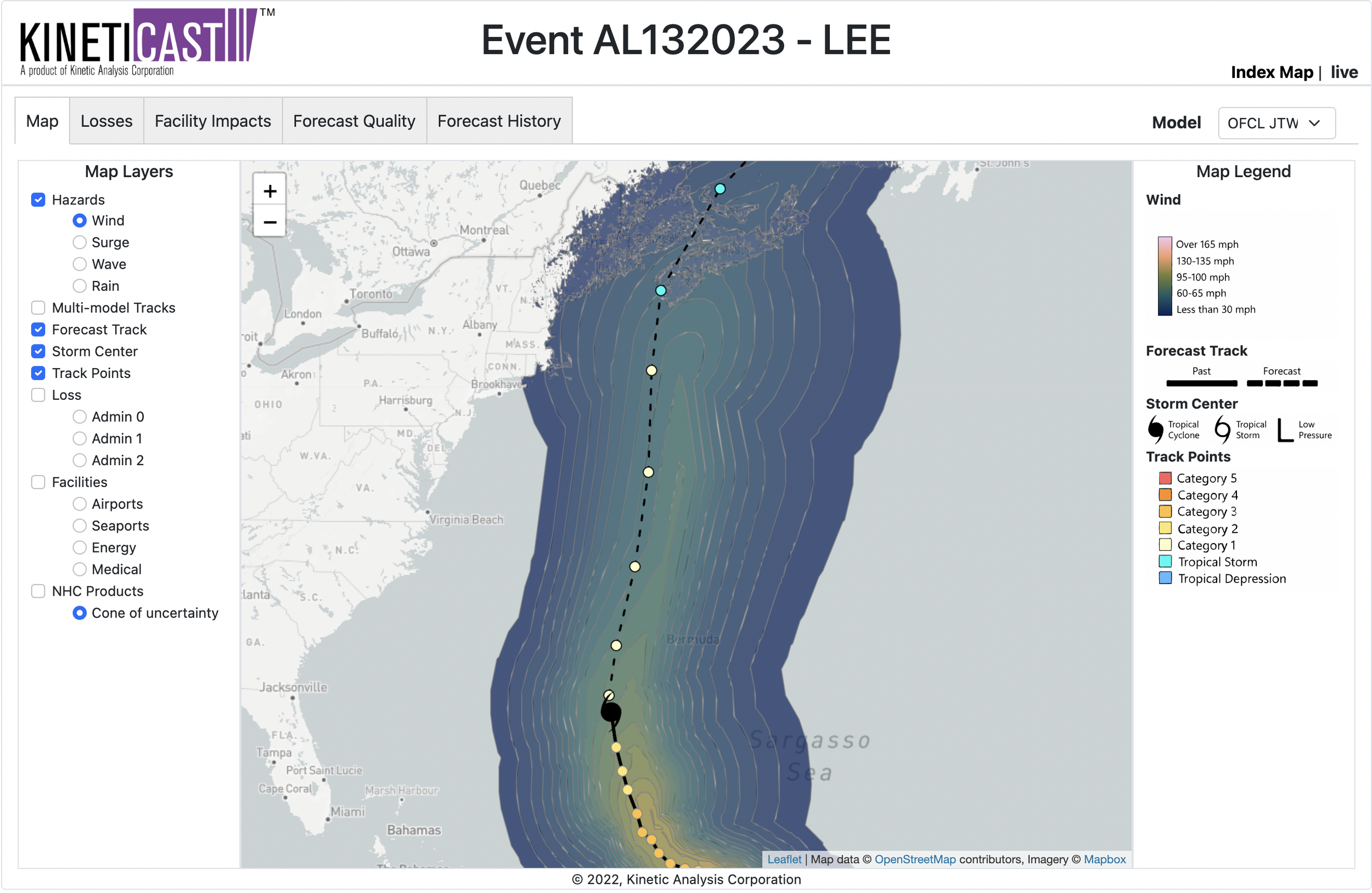
Figure 1: Projected wind swath of Hurricane Lee, generated by KinetiCast™ models using forecast data from the National Hurricane Center. The closed tropical cyclone symbol denotes the storm position for this forecast. The filled circles are color-coded by intensity. The circles on the dashed line represent the forecast position of the cyclone at 12-hour intervals, and the circles on the solid line depict the past position of the storm at 6-hour intervals.
Figure 1 shows that Bermuda is well within the envelope of projected tropical storm-force winds from Hurricane Lee, with parts of the island potentially seeing winds as high as 55-60 mph. This is sufficient to cause power outages, tree damage, and minor damage to more susceptible buildings. Fortunately, the core of hurricane force winds is not forecast to affect Bermuda currently. In addition, Bermuda’s current building code requires that residential buildings can withstand 3-second gusts of 150 mph so building damage will be limited.
After Lee scrapes by the island late tonight and into tomorrow morning, the system will begin to accelerate toward North America. Current modeling and forecasts predict a landfall somewhere along the western coastline of Nova Scotia (near Yarmouth, Canada), but it is possible that this track wobbles a bit to the east or west. Notably, any slight deviations to the west in the track may result in a landfall closer to the coastline on Maine instead. Lee will be weakening and undergoing a transition from a tropical to an extratropical cyclone in the coming days as it nears a landfall [1, 2, 3]. While the maximum winds will likely continue to weaken, the extent of these winds may continue to grow. As such, this will be similar in magnitude to a strong Nor’easter event for many in New England and Atlantic Canada [4].
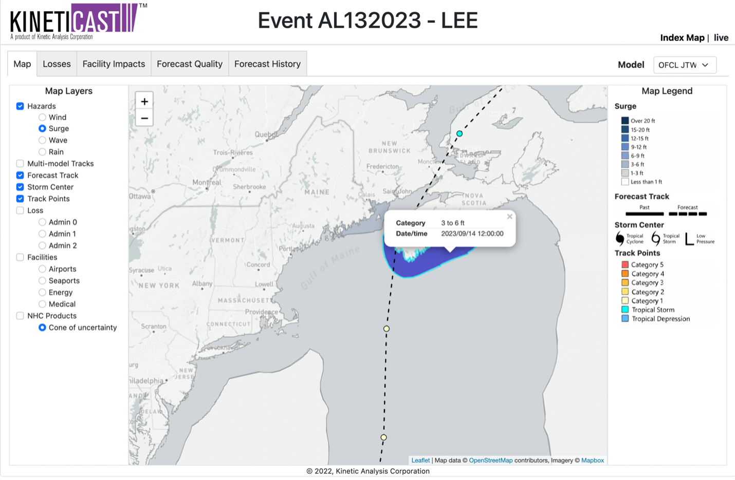
Storm surge is another threat posed by Lee, as the counterclockwise flow around the large circulation will result in an onshore flow for parts of New England and Nova Scotia. Figure 2 shows an area of 3 to 6 feet of water above normally dry ground that could impact a large part of the coastline of Nova Scotia and potentially eastern Maine. In addition, the wind impacts will be spread over a large area once the system approaches landfall. Several New England states, such as Massachusetts, New Hampshire, and Maine, as well as portions of Canada including New Brunswick and Nova Scotia will see winds as high as 40 to 60 miles per hour as Lee approaches over the weekend (Figure 1). This means that the same impacts forecast for Bermuda can be expected over a much larger area of North America in the next few days. Currently, economic losses from Hurricane Lee on KinetiCast™ are projected at roughly 100 million USD in Purchasing Power Parity, with over 90 million of these occurring in Canada (PPP is used to allow for quick comparisons between countries of different economic levels).
Figure 2: Forecast storm surge for Hurricane Lee, generated by KinetiCast™ models using forecast data from the National Hurricane Center. The surge calculation includes the cumulative effects of pressure, wave setup, wind-driven water rise, and astronomical tides.
With the peak of the Atlantic hurricane season here, activity remains elevated. A record warm Atlantic Ocean may signal the continuation of tropical cyclone activity into late fall [5]. The western Pacific has also output many impactful typhoons in recent weeks. Now is the time to ensure that you/your organization have an organized hurricane response plan in place. At Kinetic Analysis Corporation, our goal is to facilitate preparedness by providing you with accurate, near real-time information about a tropical cyclone as it unfolds. We do this by synthesizing data from a variety of sources and translating the meteorological hazards into easily understood impact information. This includes populations affected by tropical storm/hurricane force winds and storm surge, economic impacts and structural damage estimates, and shutdown times for facilities such as airports and seaports. All this information is available in our state-of-the-art web app, KinetiCast™. If you would like more information, please reach out to aagastra@kinanco.com.
References:
1. https://www.fox4news.com/news/hurricane-lee-latest-tracking-path
2. https://www.nhc.noaa.gov/
3. https://www.tropicaltidbits.com/
4. https://www.axios.com/2023/09/13/hurricane-lee-risk-new-england-maine-canada
5. https://www.corelogic.com/intelligence/record-atlantic-ocean-temperatures-bring-storms/#:~:text=The%20basin%2Dwide%20average%20temperature,than%20any%20year%20on%20record.


